為什麼山會長得這麼高?
研究人員分析世界各地的山脈之後,證實一項關於侵蝕和山脈高度關係的理論並非全然正確
By Danielle Torrent Tucker
地球上的高山與谷地千百萬年來不停變化,形成的層巒疊嶂交織成我們今日所見的壯麗地景。山脈的形成原因通常是地表下方有壓力往上推擠,但影響它們最終能長到多高的因素卻有很多,像是山峰之間的侵蝕作用,也就是河道的形成過程。
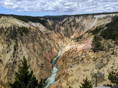
一條河川流過美國懷俄明州黃石公園的群山之間。新研究測試了一項三十年來有關侵蝕作用與山脈高度的理論。圖片來源:Seth Cottle/Unsplash
許久以來,科學家假設地表加速隆起而形成山脈時,高度也會以可預期的方式不斷增加。但是新研究指出這種推論對於極為陡峭的山脈來說可能無法成立,因此它們的高度有所限制――而且地球上所有山脈或許都是如此。
研究發表於9月16日的《自然―地球科學》(Nature Geoscience)。史丹佛大學地球能源與環境科學系的地質科學教授George
Hilley是主要作者,他說::「長久以來,人們認為隨著河道越來越陡,侵蝕速率也會跟著增加。我們從實際觀察的結果中發現,這項理論一般來說十分準確,但到達某個臨界點之後便會失效――似乎有某個我們不甚瞭解的事物突然介入。」
研究人員分析委內瑞拉、巴西、瓜地馬拉、哥斯大黎加、台灣這些熱帶地區中的許多山岳地形,並且以岩性與氣候狀況為控制因子來進行對等的比較。他們發現山岳到達特定的高度之後,突然山峰之間的河流侵蝕作用就會對河道坡度的微小變化極為敏感,使得上方的山嶺無法繼續長高。他們把世界各地數百座山脈的數據統整起來之後也發現類似的模式:地形的高度(或稱起伏)在到達某個臨界值之後,便會因為河道坡度而面臨上限。
「在瞭解山脈的高度如何隨著氣候和陸地碰撞而變化時,其中一個基本概念是河道上方的區域可能受控於河流下切的速率。」Hilley表示,「我們觀察到的特殊現象並不好解釋,現行理論不一定可以預測出來。」
研究帶來的影響
研究證實了山脈高度會受此神秘因子的作用,進而對其他研究造成影響,像是探討山區的侵蝕速率跟氣候之間的關係。這兩個因素在瞭解古代氣候並預測未來的氣候模式時相當重要。
Hilley表示:「我們的成果對這類研究中的一部分增添了有趣的面向。氣候使侵蝕作用增強或減弱時地形也會跟著變化,但過程可能會因為逐漸靠近臨界值而有所改變。」
科學家為了瞭解我們腳下看不到的板塊運動,因此對於造山運動和地球物理的關連很有研究興趣。而這項成果在此方面也有啟發。
「像我這類的科學家總是希望可以透過實際看到的地形,來得出斷層滑動的速率大概有多快。」Hilley表示,「我們的結果顯示在陡峭程度一般的地形中還是可以這麼做,但地形變得更加陡峭後難度可能就會增加許多。」
全球通用的模式
科學家進行這項研究時用的方法從出發點就很不同:他們搜尋全球找出可以顯示山脈高度變化的條件,而不是只專注於某個地區。這種搜尋方式讓他們的研究對象集中於熱帶的山脈,但結果可以適用於全球,甚至可以用來了解古代的地形。
「喜馬拉雅山以相當快的速率抬升,使得出露的岩石十分堅硬,因此測量喜馬拉雅山得到的數字理所當然地會很靠近臨界值。」他說,「這個臨界值不只可以適用於當今的地形狀況,事實上也為古代喜馬拉雅山的地形樣貌設定了大概的上限。」
Hilley表示研究結果令人感到相當驚訝,而且跟全世界的數據比較時仍然可以適用。
「事後從地球整體的真實樣貌來看,研究結果確實相當合理。」Hilley表示,「這清楚挑明了一項事實:為什麼會有這樣的現象可能是一個相當值得探討的問題。此外,結果也指出河流下切的過程中,可能還有某些事物是我們尚未完全了解的。」
Why are mountains so high?
Researchers have analyzed mountain ranges worldwide to show that a theory
relating erosion and mountain height doesn’t always add up.
Over
millions of years, Earth’s summits and valleys have moved and shifted,
resulting in the dramatic landscapes of peaks and shadows we know today.
Mountains often form when pressure under Earth's surface pushes upward, yet
many factors impact their ultimate height, including the erosion of the areas
between mountains, known as channels.
Scientists have long assumed that as land is pushed
faster upward to form a mountain, its height increases in a continuous and
predictable way. But new research shows that these predictions may stop working
for the steepest mountains and therefore limit their height – and this may hold
true for ranges on the entire planet.
“People have argued for a long time that as channels
get steeper and steeper, the erosion rate keeps increasing,” said George
Hilley, a professor of geological sciences at Stanford University’s School of
Earth, Energy & Environmental Sciences (Stanford Earth) and lead author of
a study published in Nature Geoscience
Sept. 16. “We find that the theory works really well until a certain point and
then it breaks down empirically – it seems as though something else kicks in
that we don't completely understand.”
The researchers analyzed samples from a broad range
of mountain landscapes across the tropics, including Venezuela, Brazil,
Guatemala, Costa Rica and Taiwan, controlling for rock type and climate
conditions to assess parallel comparisons. They found that after mountains
reach a certain elevation, channels between mountains suddenly become extremely
sensitive to subtle changes in their inclines, thereby limiting the height of
the mountains above. They added data from hundreds of mountain ranges worldwide
and found they followed a similar pattern: the height, or relief, of the
landscape is capped after crossing a threshold driven by channel steepness.
“Areas of land above channels are likely being
controlled by how quickly a river can cut down – this is the framework by which
we understand how the height of mountains varies as a function of climate and
the collision of continents,” Hilley said. “The anomaly we observed is kind of
a mystery and is not necessarily what conventional theory might predict.”
Research impacts
By bringing evidence of this mysterious factor
influencing mountain height, the research could impact other work, such as
studies on the relationship between mountain erosion rates and climate –
important elements for understanding ancient climate and forecasting future
patterns.
“Our work adds an interesting depth to some of these
studies, because the way in which Earth’s topography changes as climates become
more or less erosive may also change as the threshold is approached,” Hilley
said.
The work also has implications for the geophysical
links of mountain formation, which scientists are interested in exploring to understand
the hidden activity of tectonic movements below our feet.
“People like me have always hoped that you could
actually use the topography in order to say something about how quickly faults
might be slipping,” Hilley said. “What our results say is that you can still do
that in landscapes that are moderately steep, but it might become increasingly
difficult as landscapes become steeper.”
Global patterns
The scientists took a fundamentally different
approach to the research by searching the globe for conditions that reveal
changes in mountain height rather than focusing on just one location. That
search led them to focus on ranges in the tropics, but the conclusions were
consistent across all regions of the globe and may also be applied to
understand ancient topography.
“The Himalayas are being uplifted pretty rapidly and
they expose pretty hard rocks, and indeed, when you measure them out, they are
pretty close to this threshold,” he said. “You might be able to take this
threshold with just the modern configuration of the landscape and actually
place some upper bound on what the topography of the ancient Himalayas looked
like.”
Hilley said the results of the study were surprising,
as well as the fact that they remained consistent when compared with global
data.
“In retrospect it makes sense when you look at it
from the overall context of what our planet actually looks like,” Hilley said.
“It really speaks to the fact that there might be lots of fertile ground to
explore why this might happen. It also points to the fact that there might be
something about the way in which rivers incise that we just don't understand
yet.”
原始論文:George E. Hilley, Stephen Porder, Felipe Aron,
Curtis W. Baden, Samuel A. Johnstone, Frances Liu, Robert Sare, Aaron Steelquist,
Holly H. Young. Earth’s
topographic relief potentially limited by an upper bound on channel steepness. Nature Geoscience,
2019; DOI: 10.1038/s41561-019-0442-3
引用自:Stanford's School of Earth, Energy &
Environmental Sciences. "Why are mountains so high?”

沒有留言:
張貼留言